
Just Drill Deeper: Available Groundwater in the Bedrock Aquifer of Eastern Virginia’s Coastal Plain
August 20, 2026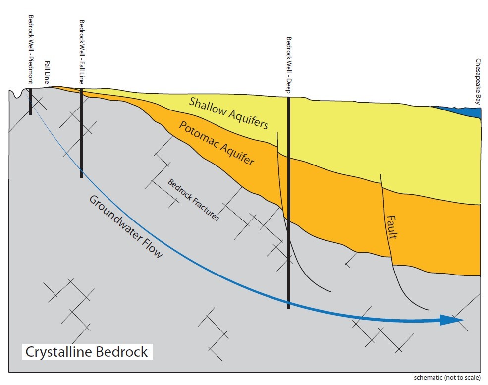
Ken Bannister
A comprehensive Virginia Department of Environmental Quality (DEQ) report warns that Eastern Virginia’s groundwater supply is severely constrained and facing a critical decline. Released under a legislative directive, the 117-page study highlights that regional aquifers cannot sustain major new water withdrawals.
In other words, without a new source of drinking water, water use in Eastern Virginia cannot continue to grow as projected without serious consequences.
Ken Bannister, Director of Geologic Services at KBJW, has studied Eastern Virginia’s groundwater supply for over 10 years. In this article, Ken breaks down DEQ’s findings and explains the technical reasoning for a simple solution: just drill deeper.
Key Findings on Eastern Virginia’s Groundwater
- Imminent declines: Supply levels in the vital Potomac Aquifer System are projected to drop sharply within the next 5 to 10 years.
- Industrial strain: Accelerated data center development, specifically those using evaporative cooling systems, and industrial pumping are driving depletion.
- Permit restrictions: The Virginia DEQ stated there are currently no areas east of Interstate 95 where a major new groundwater withdrawal permit can be safely approved.
- Environmental risks: Excessive pumping has dropped water levels below sea level, causing land to sink and accelerating saltwater intrusion into freshwater wells.
Due to the urgency of the DEQ findings, state lawmakers are actively urging a special legislative session to enforce stricter water conservation rules and protect the region’s clean drinking water. The only alternative to stricter conservation would be adding a new source of drinking water to the system.
The Only Potential “New” Source Under Review
Scientists with the US Geological Survey have previously researched the unconfined surficial aquifer (shallow groundwater) as a minor alternative source. However, tap options are heavily restricted because extracting from this shallow layer risks disrupting local streams, wetlands, and coastal ecosystems. The water quality is also generally of poorer quality. It’s for these reasons that conservation and wastewater treatment strategies are favored over developing shallow groundwater resources.
An Alternate Groundwater Supply DOES Exist—Just Drill Deeper
A separate aquifer lies beneath the aquifers currently experiencing shortages, and this deeper bedrock aquifer is not subject to the same groundwater shortage. This is the same aquifer that supplies groundwater to every drilled well west of I-95 in Virginia and recharges the affected aquifers at the Fall Line. However, permitted withdrawals east of the Fall Line exceed recharge from the bedrock aquifer, causing declining water levels and limiting additional supply. Hydrographs from this aquifer show no declining water levels. The solution is simple: just drill deeper.
Reasons Why We Haven’t Drilled Deeper (Yet)
The most frequently given reasons as to why this solution has not been implemented are:
- We have not needed to.
- The technical challenges are too great.
Given the situation in Eastern Virginia, the first reason is clearly no longer valid. A new source of water is needed to avoid stricter water conservation rules. As for the technical challenges, Ken further breaks down common technical concerns associated with deep bedrock wells and explains why drilling deeper is worth exploring further.
Evaluating Technical Challenges
The additional technical concerns raised are better understood as issues to evaluate, address, and test rather than fatal flaws in the concept. They are legitimate considerations, but none rule out further exploration of this aquifer. In fact, these unresolved questions are precisely why the Eastern Virginia Groundwater Advisory Committee recommended additional investigation.
First Challenge: Virtually No Water Flow
Unlike the porous, water-storing sand and gravel layers of the sedimentary Potomac Aquifer, basement bedrock is dense, solid rock. Groundwater in western Virginia bedrock only exists because the rock is highly fractured near the surface. Under the immense weight of the Coastal Plain, these fractures are tightly compressed and closed, meaning the rock holds almost no extractable water.
First Response: Documented Fractures
Fractures do exist at depth and can carry fluids such as oil, gas, geothermal resources, and groundwater. Research has identified major fracture systems beneath the Virginia Coastal Plain, and fractures and faults do not simply disappear eastward across the Coastal Plain. Many faults are documented in publications that support the current DEQ groundwater model. If basement faults have been mapped and published by the USGS, associated fractures are also present; faults are simply fractured rock zones that show evidence of movement.
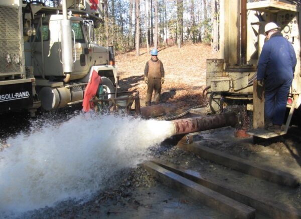
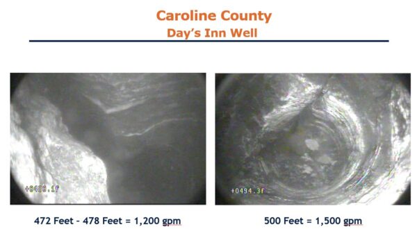
The well in the photo below shows a 1000 gallon per minute found by the author in Caroline County, fed by deep fractures in the bedrock aquifer, and located about a half mile west of I-95. These fractures do not disappear just because you move to the other side of I-95. Data showed a total of 1.5 million gallons per day in this system from bedrock wells. Water in this aquifer is flowing eastward, some recharging the sedimentary aquifers, but some flowing beneath it, uncaptured. The second photo shows the actual fractures feeding this well, taken by Brad White – DEQ, a few days after it was drilled.
Second Challenge: Prohibitive Depth and Cost
Along the fall line (near I-95), the bedrock is relatively close to the surface. However, as you move east toward Chesapeake Bay and the Eastern Shore, the bedrock slopes sharply downward. In coastal areas, it sits thousands of feet beneath the surface. Drilling to these depths is economically unfeasible for public or industrial water supplies.
Second Response: Other Costly Solutions Already Drill Deep
The Hampton Roads Sanitation District (HRSD) Sustainable Water Initiative for Tomorrow (SWIFT) project is already drilling to the bedrock surface in the eastern Coastal Plain to inject treated wastewater into the aquifer, demonstrating that the technology exists locally and that the approach can be economically justified for wastewater management. The billion-dollar SWIFT investment will protect surface water quality and help address the current groundwater challenge. If drilling to the bedrock surface is feasible for disposal, then extending wells a few hundred feet deeper to reach valuable drinking water supplies may also be economically reasonable, especially if it helps avoid billions of dollars in economic losses. Additionally, not all bedrock wells need to be as deep based on hydrogeologic data.
Third Challenge: Extremely High Salinity
Water trapped at the bedrock boundary is stagnant and has been isolated for millions of years. Because it has dissolved minerals from the surrounding rock over millennia, any trace water found at these depths is highly saline, brackish, or toxic, requiring intensive desalination to be usable.
Third Response: Untested Claim and Success in Other States
Because deep well drilling has not yet been tested here in Eastern Virginia, those assumptions cannot be confirmed. In nearby states where this approach is being used, even mildly brackish water is being treated and put to use successfully, making deep wells the preferred solution.
It’s impossible to determine water quality until you drill, especially to depths not previously drilled, nor into aquifers that have not been explored. Some mapping exists to make an educated guess, but it is ultimately a guess. This is entirely the point of looking deeper without broad assumptions that it will not be suitable for use.
Different uses have different water quality standards, so what may not be suitable for drinking may be suitable for industrial use. The model used by DEQ treats the boundary between the Potomac aquifer and the Bedrock Aquifer as a no-flow boundary. Data from other states implementing this solution show that even slightly brackish groundwater is a very economical option. Moreover, data show that this deep system is potentially hydrologically isolated from the hyper-saline brine of the Chesapeake Bay Impact Crater, yielding water that is fresh or highly treatable.
Fourth Challenge: The Impact Crater Factor
A massive, ancient asteroid impact created the shattering the deep bedrock structure in eastern Virginia. This unique geological feature permanently fouled the deepest water layers with hyper-saline brine, making the deep subsurface even less viable for freshwater extraction.
Fourth Response: It Depends on Where You Drill
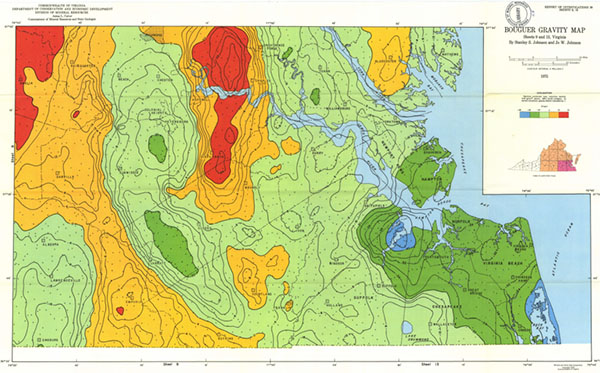
The crater’s effects are limited to a relatively small area near and beneath it. However, the crater also redirects eastward-flowing groundwater and concentrates it in zones that may be easier to capture. Research has identified a possible smaller nearby bolide impact that may have formed a vertical conduit, allowing fresh groundwater to rise near the saltwater interface and potentially supporting the Dismal Swamp. It is shown by the bullseye feature below in the Nansemond River.
Continue the Conversation
Ken Bannister invites anyone interested in exploring a deep bedrock well solution to Eastern Virginia’s projected water shortfall to contact him and continue the conversation. Ken and KBJW’s team of geologists have the expertise and experience needed for a new approach to Virginia’s water resources strategy.